Salcantay (Nevado Salcantay) or Salkantay (Nevado Salkantay), Sallqantay in Quechua is the highest peak of the Cordillera Vilcabamba, part of the Peruvian Andes. It is located in the Cusco Region, about 60 km (40 mi) west-northwest of the city of Cusco. It is the 38th highest peak in the Andes, and the twelfth highest in Peru. However, as a range highpoint in deeply incised terrain, it is the second most topographically prominent peak in the country, after Huascarán. (Wikipedia)
This is truly a spectacular trek, and I hope that by providing this information, it may encourage more people to attempt it this trek on their own. There is a lot of vague and misleading information on the web, and we found it very hard to find decent information beforehand when planning our trip. One of the best resources by far that I came across while planning was Vova & Olga’s very accurate and detailed Salkantay Trek Report. This was integral in making our Salkantay trip a success, and we owe them a lot of gratitude for the information!
Jump to:
Day 1 – Cusco to Mollepata
Day 2 – Mollepata to Soraypampa
Day 3 – Soraypampa, Abra Salkantay, Huaracmachay, Chaullay
Day 4 – Chaullay, La Playa, Lucmabamba
Day 5 – Lucmabamba, Llactapata, Hydro Electrica, Aguas Calientes
The Basics
The Trail: The trail begins in the small town on Mollepata, about 60km north west of Cusco. It’s about a 2-3 hour bus ride from Cusco to Mollepata. From there, the trail climbs high into the Cordillera Vilcabamba, reaching an altitude of 4,800 meters at Abra Salkantay (the pass) before descending into lush tropical forest, and finally reaching Aguas Calientes, near the base of Machu Picchu. In general, the trail is very easy to find and follow, and whenever there is any doubt there was always a helpful local around to point the way.
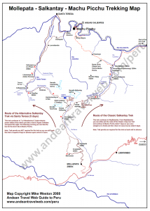
Maps: You can find a more or less comprehensive list of maps here. Of particular use is this chart (all credit to the original author!) listing approximate hiking time between points of interests, along with elevations of each point. We were able to successfully complete the trail without getting lost with only a printed copy of the Salkantay Trail Map from Andreantravelweb (at right). This is a suitable (though not to scale!) map, which shows most major landmarks and villages. As for printed maps, by far the most recommended and best I have seen (scale, topographical map) is the IGN 1:100000 Machupicchu (sheet 2344, 27q), however this does not actually show the trail and it’s quite expensive (around S./50 in Cusco). Also, I have created a simple google topgraphic map (at the top of this page), with most points of interests labeled and a rough line of the trail overlaid.
Getting There: From Cusco, buses leave from Avenue ACROPATA, everyday, starting at 05:30. They leave approximately every hour, with the last bus departing from Cusco (in theory) at around 12:00. The cost is S./7, and the trip takes about 2-3 hours. Past Mollepata, you have a few options: The first section of the trail from Mollepata to Soray is a relatively easy walk along a grated gravel road. However, this is the least interesting part of the trail, and I would probably recommend to skip this and catch a ride… First option (expensive): take a taxi from Mollepata to Soraypamapa and begin the trek from there. This will cost about 100-200 soles, depending on who you ask. Second option (cheap, but painful!): you can try to flag down one of the few trucks that will pass along the road, and give them a small payment for the (rough!) ride. Thirdly, you can of course choose to walk, which will take you about 6 hours from Mollepata to Soray.
Money and Fees: There was some talk in 2008 about making this trail ‘official’ and therefore implementing fees and regulations. To my knowledge, this has never been done, and nowhere along the trail did we notice any fee or post stations, or indeed, anywhere it even seemed likely that they could be located. To date, this trail remains FREE and unrestricted! Let’s hope it stays that way…
As for money, people in these small villages have very little money to give change. Bring plenty of small bills (like ten soles) if you wish to buy things along the trail like snacks or water, or pay for official campsites.
Safety: There are plenty of comments around the web about the dangers of attempting this trek without a guide: Getting lost, injured, robbed, etc. As I mentioned earlier, the trail was very easy to follow, and when in doubt the locals were nothing but friendly and helpful. Remember, this is NOT wilderness trekking! I think the farthest distance between two points of ‘civilization’ is between Soray and Huaracmachay, over the pass. This is about 6-8 hours where you will not pass a town, but the trail is VERY easy to follow here, and very well trafficked in case there are any problems. The rest of the trek you will be passing through small villages, or near to roads, where you will be able to find at least some kind of aid in the worst case situation.
At no point on this trek did we feel in any way threatened in any way by the people we met- On the contrary, they seemed to go out of their way to be helpful and welcoming, and to offer in advance whatever they could! I think a lot of this misinformation comes from the tour operators simply trying to prevent people form attempting this trek solo, and to keep the business going.
If attempting this trek alone, just remember that there are certainly dangers, but by being properly informed and prepared they should be minimal! Enjoy!
Further Information
Food and Water: Water was very easy to find along the trail, though you should bring some form of purification when you are drinking water from streams, as there are usually cattle and other animals in the area that can cause contamination. Food should be kept simple and light- instant soup and granola bars go along way on a high-altitude trek. You definitely want to keep the weight to a minimum. There is also the possibility to buy both food and water along the way in the various kiosks and campgrounds you will pass, however this should not be counted on. Be prepared with at least 2-3 days of food as a minimum.
Clothing: I would highly recommend to take along only ONE set of clothing (just the ones you are wearing!). Yes, I know… five days… but you can do it. Take plenty of layers because the pass (4,800m) and higher sections of the trail can be very cold- Nights can be below freezing, and days in the lower altitudes are very hot. A warm and light sleeping bag is essential, as are sturdy shoes and socks.
Other Supplies: A small jet-stove or camp-cooker to prepare simple meals, along with fuel for five days. High SPF sunscreen is essential as the sun is very harsh at high altitudes. Bug spray is also very helpful as, after the second day, you will descend into tropical forests and the biting gnats were vicious! A simple but adequate first-aid kit should also be included in the supply list.
Altitude Sickness: The highest point along the trek is at 4,600-4,800m at the pass. Altitude effects everyone in different ways, but at the very least you will probably feel the thin air when you are puffing your way up the last few hundred meters to the pass. More serious reactions can include, headache, dizziness, nausea, and loss of appetite.
It is very important to be acclimatized before attempting this trek. The rule of thumb is to spend at least three days in Cusco (3,350m) or some similar altitude to allow your body to make adjustments. If you can, try a few smaller hikes (there are some beautiful and very accessible ruins near to Cusco) before setting out for Salkantay. This will give you a bit of a feeling for how your body will react, and how well you can preform in higher altitudes.
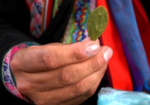
Coca leaves are your best friend for altitude sickness (forget the pills!). Coca leaves are widely used throughout Peru and seem to cure practically everything. They help significantly in dealing with altitude sickness, as they improve oxygen absorption, reduce fatigue, as well as provide many vitamins and minerals. Check the wiki. Trust me, buy a bag in the market before you set out and you won’t regret it- Mate de Coca is the best way to wake up in the mountains!
Horses and Mules: Just because you decide to go it alone and skip the guide, doesn’t mean you have to lug your bag over the pass! There are plenty of people along the way who will be willing to help you carry your bag if you so desire (for a minimal fee!). In Soray, we asked around and found a very friendly old man who took our two approximately 12-15 kilo bags over the pass for us for 50 Soles. By the time you make it to the pass, exhausted and out of breath you will be amazed at the value- Highly recommended service! Also, throughout the trail you will pass plenty of mule trains carrying supplies to and from the various villages. They too will be happy to add one more bag to the load for a small tip.
CONTINUE TO: Day 1 – Cusco to Mollepata


 | Powered by
2 Comments on "Salkantay – Introduction"
You must be logged in to post a comment.